Wednesday, December 14, 2011

The Distant Future of Montevideo

For my consideration of Uruguay 100 million years into the future, I consider two climactic possibilities. 
It is important to note that for both considerations I will assume that the Milankovitch cycles will have returned to the status they are today due to difficulty in predicting their interactions to such a future date. Secondly I will assume that by this time anthropogenic influences will be minimal either due to catastrophic extinction of humanity or an enlightenment of the human race coupled with advances in technology that allow them to live harmoniously with natural ecosystems.  


The first shall be represented by this map:
http://www.youtube.com/watch?v=pGACbD4zbWs
 According to this simulation Uruguay will still remain in the Southern Hemisphere but it will have moved much closer to the equator. My approximation of latitude will be 10 degrees South with Longitude at about 18 degrees West. At this new more northern location, the sun's angle will be much more perpendicular to the ground year round and will result in higher temperatures. Additionally, this location will be right below the ICZN and the subsolar point. As the sun warms the region, the hot air will rise and give off its moisture resulting in heavy rains. Given that Montevideo will still be off the coast, it is likely the air will be saturated.

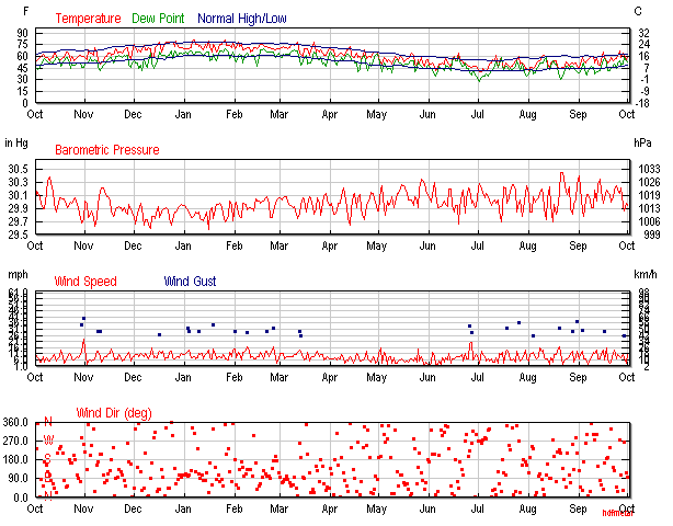
Predicted climograph for Uruguay 100 million years into the future.
Temperature in burgundy and precipitation in purple.

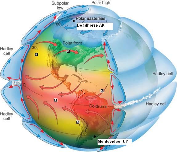
Seasons will remain during the same time of year but given the proximity to the equator, it is unlikely much of a difference will be seen from month to month. With the location near an ocean and given the now limited amount of land in the southern hemisphere, I do not expect a lot of air mixing and therefore I feel temperatures in the area will remain constant. Any air circulation will most likely be influenced by the Doldrums.

Notice the location of Uruguay just south of the low pressure system

Tectonic activity throughout South America will be limited over the next 100 million years so it is unlikely a mountain range should develop anywhere near Uruguay and thusly eliminate the potential for a rain shadow or other orographic interferences with climate. Montevideo's location on a passive margin makes it unlikely that any geologic lake formation should occur either. The only fluctuation in lentic and lotic systems should depend on increased precipitation and sea level fluctuation.

http://www.globalchange.umich.edu/globalchange1/current/lectures/evolving_earth/evolving_earth.html
Uruguay is located on a passive margin that will experience little tectonic activity. Montevideo indicated with pink dot.


Air masses will no doubt change globally but given the northward migration of South America and its relative isolation, I expect only maritime equatorial and continental tropical influences. 

Maritime equatorial in red, Continental tropical in pink


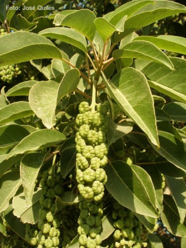
Vegetation in Uruguay will likely change from grass lands to tropical rain forest. Average relative humidity will be high year round but the foliage should keep the suns rays from striking the ground directly and keeping the heat more moderate.


For the second simulation I consulted this map:


As you can see, temperatures would still be high as Uruguay migrates to the equator but a rise in sea level with no potential tectonic uplifting would mean that Montevideo would exist only as an underwater ancient city.


Tuesday, December 13, 2011

Montevideo 100 mya

http://www.planetaryvisions.com/Project.php?pid=2216

One hundred million years ago, Uruguay was in a more southern location much closer to Africa. Perhaps closer to 45 degrees latitude and 15 degrees east of the prime meridian.Global temperatures were much higher at the time so despite being at a lower latitude, temperatures would have probably remained closer to the same as modern day Uruguay.
Air masses during the Cretaceous would have no doubt been in different locations and would have offered differing effects on past temperatures. With the development of the new Atlantic Ocean, permanent current patterns would have just begun to form but assuming a shallower sea level, they would have not had the depth to be influenced by flow from the colder Arctic and Atlantic water as they are in today's ocean.

A proposed map showing potential locations of ancient climate air
masses that might have affected Uruguay. Red indicates maritime
tropical, gold continental tropical, light blue maritime polar and pink
as a developing maritime tropical air mass over the very warm shallow
Atlantic sea. 

It seems reasonable that the warm shallow sea to the east would have begun to moderate the climate of Uruguay and made it slightly warmer than modern Montevideo. The forming ocean most likely increased humidity in the air and caused a rise in precipitation levels but nothing that would have by that time created the more lacustrine environments seen in Uruguay in later years. Because there was slightly more land mass in the southern hemisphere at the time, there might have been a bit more variety in seasonal temperatures.


Climograph for Modern day
Uruguay


Climograph for Cretaceous Uruguay. Temperature in burgundy
and precipitation in purple.

Monday, December 12, 2011

Climate comparison of Uruguay to Deadhorse Alaska

According to http://wx3232.blogspot.com/ The climate of Deadhorse is listed as DFC. DFC climates are typically very cold for long periods of time in the winter and have cool mild summers.
The variability of the temperature is in stark contrast to Uruguay which enjoys mild and fairly constant temperatures.

Temperature shown along red dotted line
Precipitation at the bottom.
Northern Alaska.


The higher latitudes of Deadhorse contribute the most to the difference in average temperatures. Despite both locations proximity to a coast, Deadhorse also experiences far less precipitation than Uruguay. The precipitation is greater in the warmer summer months, occurring the opposite time of the year with Deadhorse being a northern hemisphere.


Uruguay
both images from:
http://cwx.prenhall.com/bookbind/pubbooks/lutgens3/medialib/abcontrol/pages/question.html 


Part of what moderates the climate of Montevideo is the location of the southern Hadley cell that creates a semipermanent high ridge over Uruguay. We can see from this image that Deadhorse is directly under a circulation cell that churns out the Polar easterly winds.
Windfinder.com shows the wind predominately blows to the East


Deadhorse vegitation is minimal and hardy, well adapted to the extreme cold conditions. The soil freezes to great depths for much of the year also limiting vegetation growth.
The average humidity in Deadhorse is still relatively high and consistent through the year because of its proximity to the Ocean.
It is likely given the number of plants that can stay green year round in Uruguay, there is more evapotranspiration contributing to the average relative humidity.

Wednesday, November 30, 2011

Climate of Uruguay

The whole of Uruguay is officially classified as a CFA climate according to the Koppen classification system, meaning it is temperate with high humidity and warm summers, as previously illustrated in Blog 1.
CFA climates are indicated in green. Image obtained from Wikipedia,
information regarding climate confirmed from instructor slides.


Atmospheric conditions influencing climate in the region are dominated by the high pressure cell. The proximity of the Atlantic Ocean contributes to the climate's humidity. Urban heat island effects are minimal although anthropogenic influences are discussed below.

Soil Types
There are a variety of soil types across Uruguay that determine the types of plants that can flourish in different areas. These plants in turn impact the climate and types of organisms. Furthermore, soil conditions influence areas of anthropogenic impact (ie soils suitable for agriculture and grazing) [4]. Pellic Vertisols and lithosols cover most of the country. These soil types offer good drainage and do not hold water too well [1]. Mollic Planosols in much of the country are rich in organic matter and support crops. The relativly flat topography and steady precipitation levels prevent major soil erosion and allow for the accumulation of organic matter.
Group I soils are vertisols and lithosols. Group III and IV are planosols.
image from http://www.fao.org/ag/AGP/AGPC/doc/Counprof/uruguay/Fig4.htm 

Plants of Uruguay


Herbaceous and grass plants dominate the native vegetation of the region. Larger native trees occur in small forest clusters and grow particularly near rivers.
Piptochaetium montevidense. A grass common
in Uruguay, now considered an invasive species
in Australia
Photo from [2]
Celtus Spinosa. A tree that commonly grows in the proximity of
rivers. [3]


Phytolacca Dioica. A variety of herbaceous
vegitation found in Uruguay that may also
grow in a tree habit [5].
The burrowing owl, pictured above, is native to Uruguay.
It has adapted to life within the grasslands and burrows
in the ground instead of nesting within trees since taller
foliage is a limited resource.


Since population expansion, native forests were cleared to make way for agricultural lands. However several native tree species were planted in urban areas as ornamental varieties. [4]
Citharexylum montevidense. Known only as
an ornamental tree [3]. Despite clearing natural
foest for agriculture, ornamental trees have seen
an increase with urbanization.


Currently there are few introduced plants from other similar climates, most notably the Eucalyptus.

Paleoclimate


Because of the flat topography and high humidity in the region, sediments are particularly well preserved in Uruguay and can give an accurate view of previous climate. Lake deposits indicate similar plant species in the region previously with roughly the same climate. Recent (ten to twenty years ago) data does not suggest any significant trends in temperature change within Uruguay. However, varying sea levels and meandering rivers have altered the status of water bodies. Data that goes as far back as the Holocene suggests that Uruguay dries out from its characteristic perennially humid state during cold periods, particularly during the last smaller ice age [6].

Isotopic analysis of lake sediments has revealed human contributions to local climate recently. Since the increased demand for agriculture and from minor contributions from urbanization, Uruguay has seen an increase in eutrophication. Increased levels of nitrogen in sediments are attributed to fertilizer runoff. Eutrophication can affect local climate by increasing the amount of carbon dioxide released during fall and spring turnover. Additionally, high concentrations of algae absorb greater amounts of sunlight and may increase lake temperatures by limiting reflectivity [7].


References
[1] http://www.fao.org/ag/AGP/AGPC/doc/Counprof/uruguay/uruguay2.htm
[2] http://www.zhiwutong.com/tu/bp/p/piptochaetium%20montevidense%2002.JPG
[3] http://micol.fcien.edu.uy/flora/uy_flora.htm
[4] http://www.worldwildlife.org/wildworld/profiles/terrestrial/nt/nt0803_full.html
[5] http://florasilvestre.es/mediterranea/Phytolaccaceae/Phytolacca_dioica2.jpg
[6] http://pages-142.unibe.ch/products/newsletters/2009-3/Special%20section/Science%20Highlights/Garcia-Rodriguez_etal_2009-3(115-117).pdf
[7] http://www.ncbi.nlm.nih.gov/pmc/articles/PMC2266883/

Sunday, November 13, 2011

Comparison of Montevideo to Lima, Peru

Both coastal cities in South America, Lima and Montevideo share many distinct differences and similarities.

Like Montevideo, average temperatures of Lima fall within a limited range year round. Perhaps the most striking difference illustrated by the two images below concerns the sporadic wind directions throughout Uruguay compared to the steady winds from the South in Lima.
Weather data for Lima from 2010 to 2011.
From http://myifrugeog3232.blogspot.com/  
Weather data from Montevideo for the same date range.
www.wunderground.com

This steady wind from the South is related to Lima's proximity to the intertropical convergence zone and the influence generated by the trade winds.
Note the direction of the winds near the doldrums relative to the approximate location of Lima.
Idealized global circulation, © Prentice Hall, Earth Science 11th ed with modifications


Both locations enjoy subtropical environments influenced by the nearby ocean however the flat topography of Montevideo contrasts to the Andes mountains in Peru. While precipitation in Montevideo is consistent year round, the Andes create a barrier that can create seasonal changes in precipitation.

Both Lima and Montevideo experience weather due to maritime air masses, Lima is primarily influenced by polar air while Montevideo enjoys tropical air. The major current off the coast of Lima is the cold water Peru current, much colder than the Brasil Current off the coast of Montevideo [1].
http://www-odp.tamu.edu/publications/201_SR/122/122_f3.htm 
with modifications

Note the average annual sea surface temperatures of the coast of Peru are slightly colder than Uruguay:
Though at first it may seem the east coast of the continent is
also surrounded by dark blue, note the warmer sky blue in the
inlet by Montevideo, closest to the continent.
http://forces.si.edu/elnino/01_00_00abc.html
Because of the cold water Peru current and large land mass that separates Lima from the Atlantic Ocean, tropical cyclones are not a severe weather issue that affect Lima. Likewise Uruguay is separated from the rest of the warm Atlantic Ocean by cold water currents to the east of the Brasil current. Montevideo is also south of the circulating high pressure system that directs tropical storms and hurricanes to the north so these types of storms are rare in Uruguay. 

Tornadoes are fairly rare occurances in both Lima and Montevideo. Occasionally, conditions conducive to tornadic activity in Brazil to the north of Uruguay can travel south and affect areas near Montevideo. The Andes mountains near Lima typically protect the region by disrupting conditions that cause tornadoes.  [2]

Monday, October 31, 2011

Isobars and Pressure Differences

For Tuesday November 1
 The map to the left shows the gradual relatively uniform lines of pressure around Uruguay.
Projected map for Nov 6th


As the week continues, pressure drops and precipitation begins to occur to the west.


 By next week, precipitation is expected.


Maps from windfinder.com


Extra Tropical Cyclone

Typically the semi-permanent high pressure system over Uruguay moderates the weather and prevents seasonal storms. Likewise, the similar densities of humid air masses creates a uniformly mild climate with uniform annual precipitation. However, in Spring 2005 a massive cyclone devastated Montevideo when a cold front moved in over Argentina, gaining moisture over the river valley to the east of the most populated city in the country.
The tropical cyclone of 2005 occurred in a more Northern latitude  than usual.
http://www.ncdc.noaa.gov